Sunday, July 30, 2006

Redwood City to Mountain View, the Long Way

My usual commute is: home to Menlo Park CalTrain, by bike, approximately three miles; Menlo Partk to Mountain View, by train, 8 miles; Mountain View CalTrain to work, by bike, two blocks.

Last thursday I did something I've been talking about for a long time, and biked the whole distance. Actually, I did this about three years ago, and had some mechanical issues en route, and ended up making a slow detour to Home Depot in East Palo Alto to pick up some tools to make it the rest of the way. Having been up late wednesday catching up on deferred maintenance on my bike, and with a pretty good assortment of tools in my backpack, I set out hoping for better luck.


My Route

I actually had a bit of a head start, since my wife and daughter were going ice-skating, and I rode along with them with my bike in the van, which cut off about two miles from what I otherwise would have ridden. The rink is near the intersection of Marsh Road and the Dumbarton rail line, perhaps the site of a future station of Dumbarton Commuter Rail.


Stately Marsh Manor

A few blocks away I left the road and started pedalling down the bayfront bike trail.
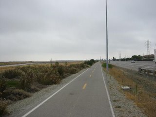

Along the Bay

The path goes along the Salt Flats for about a mile and a half or so.


If it could rain on the moon, it might look something like this

Eventually you reach the approach to the Dumbarton Bridge, and cut through a bit of East Palo Alto. The route's not clearly marked, but eventually you can work your way through to more marshlands on the other side.


Some of the trails are paved, some are not


Some go through, others are dead ends, but at least the dead ends have nice views


Occasionally you see wildlife


Or other points of interest; this is an abandoned club house from the long-silted-up Palo Alto Yacht Harbor


A truck school was testing students on the back streets of Mountain View

Eventually the trail leads to Shoreline Park in Moutain View, where it connects with the Stevens creek trail. About this time I was starting to get hungry, and noticed a mother and kid picking blackberries. I stopped a ways down the path and followed suit. I must have ridded up a little to close to the bramble, because as I started up again, I noticed my back tire was getting a little squishy. It was a slow leak, but not too slow, and a patch kit was not one of the tools I had in my backpack. I originally planned to take the Stevens Creek trail all the way to downtown, crossing over the tracks on that cool bike bridge, but took the next exit to Moffett Drive, and hoofed it while I still had air. I started hearing the klunk-klunk-klunk that means you're really out of air and need to start walking just about as I reached the Mountain View CalTrain station, and walked the last two blocks to work.


Moffett Blimp Hangar

Thursday, July 13, 2006

Coordinating Transit: How About Starting with a Map?

Coordination between Bay Area transit agencies is pretty much non-existent. I mean, if you try transferring from one to another, even at one of the officially designated connection points (say for example CalTrain to BART at Millbrae) chances are pretty good that you'll either get off one train just in time to see the one you wanted to catch leaving, or if not it will leave while you're fumbling with change to buy your next ticket.

When it comes to Bay Area transit, it's always good advice to bring exact change and something to read.

But to me, something that really drives home how totally uncoordinated our area transit agencies are is this: you can't even get a map that shows them all. Try Google, try the official Bay Area Metropolitan Transportation Authority ("...coordinating transportation for the nine county San Francisco Bay Area") website; I defy you to find one.

Perhaps this is where the geniuses at the MTA, who seem totally incapble of coordinating schedules, or coming up with a unified ticketing system (no, TransLink is not a solution, just a kludgy workaround) might try to take their first "baby steps" towards building an actual integrated regional transit system: print a damn map of what we have now.

Wednesday, July 12, 2006

Where to Eat

So where do you go when you get hungry while you're out about on public transit. Here's a few places we've liked, or at least gone to more than once.
  • Peet's Coffee has set up shop in a lot of great transit-watching locations, such as the Ferry Building, Market between Church and Castro (watch the F line), and across the street from CalTrain in Redwood City. There are also Peets's easy walks from the Belmont and San Mateo CalTrain stations.
  • The Old Spaghetti Factory in San Jose is really only ho-hum, but it's near Diridon station and if you have some time to kill (say, for example, you're getting on a bus to L.A. at the nearby Greyhound station and it doesn't leave til 11 P.M.) downtown San Jose doesn't give you many other choices. Plus they have an old Birney streetcar inside the restaurant.
  • Mitchell's Ice Cream is just fantastic. I mean, I've seen lines out the door on rainy nights. If you want to try something exotic, get ube (which is bright purple), but really, even their vanilla is pretty damn good. It's about a block from the Muni's J Church.
  • Top Dog Hot Dogs is yummy and a block from downtown Berkely BART.
  • Fremont Wienerschnitzel; hey, Wienerschnitzels are getting hard to find these days. This one is half a block from the Fremont Centerville Amtrak/ACE station, which has a coffee shop with outdoor seating, which also happens to be closed on weekends, making it a pretty good place to eat a hot dog and watch trains.
  • Food court, Hillsdale Mall; acros El Camino from Hillsdale CalTrain (walk north from the station, past TGI Friday's, enter the mall through Sears--just crossing El Camino the most direct and obvious way kinda sucks. I recommend the hybrid Chinese/Cajun place (not kidding here).
  • Popeye's Chicken, 22nd & Mission, two blocks from 24th St. BART. I never actually made it to this one, and now I'm on a diet. Argh! Go and eat a biscuit for me.
  • Franklin St. Cafe at Redwood City CalTrain, right by the tracks.
  • Downtown San Mateo has lots of good eats within an easy walk from CalTrain. North Beach Pizza and Pizza My Heart are pretty good, but we seem to keep going back to Mr. Pizza Man.
  • Cafe Maison coffee stand at Mountain View CalTrain; many times I haven't gotten enough breakfast and picked up a croissant and a hard boiled egg for $2.00. At lunchtime the hotdogs are ok too.
  • Crêpes Café at Menlo Park CalTrain. The crêps are yummy, both savory and sweet, and the coffee's good; plus they have free wi-fi, and it's close enough to the station that you can sit on the deck until you hear the crossing bells, and still run over in plenty of time to catch your train (going southbound, anyway).
  • Cramer's Bagels; Silicon Valley is full of these Bagelwich places, usually run by Vietnamese immigrants. This one is particularly good, and happens to be in a strip mall across the street from the Santa Clara CalTrain station--where you might happen to find yourself hungry and with time to kill, if, for example, you just flew in at SJC on a weekend, when trains run hourly (take the VTA's #10 bus, which is free, from the airport to the station). Be warned the bagels are big; as I write this, I am fighting off a case of the post-lunch drowsies from eating there.
  • Indulge Asia Buffet, across the street from Belmont CalTrain. "A lot of commuter trains and SamTrans bus traffic in this corner! Makes for an enjoyable scenary while getting a bite to eat!" -- George G.
  • Yumi Yogurt across the bus circle and parking lot from Sequoia Station, Redwood City. The low calorie/carb/fat flavors are yummy and good for you!
  • MiMe's Cafe in downtown Redwood City. Actually part of a culinary arts training program for young people--who are really nice and make, imho, the best lunch in Redwood City. Sometimes you get free dessert, too!
So what are your favorites? Leave a comment and let us know!

A satisfied Mitchell's customer enjoying a cone of ube ice cream.